 Casa Loma
Slope Soaring Site
Description: A few miles off Interstate 80 in the Tahoe
National Forest, this southeast facing site overlooks the North Fork American
River canyon. This site, besides having
a spectacular view, complements the others sites with flying during both the
summer afternoon SW “delta breeze” and the stronger winter prefrontal SE winds. Access is via a paved road, and you can
drive to within 50 yards of the flying site.
Location: This site is
located about 28 miles and 39 minutes from Grass Valley, and is a little more
than half way from Sacramento to Tahoe on I80.
From Grass Valley, take 174 to
Colfax at the junction with I80. Travel
NE on I80 from Colfax about 11.3 miles and exit at Alta. This exit is about 2.5 miles beyond Gold Run
and about 1.5 miles beyond Dutch Flat.
At the Alta Exit, turn right at the stop sign, then an immediate left on
Casa Loma Road, more of a zigzag than two turns. Set your odometer here.
At 0.8 miles, turn right still on Casa Loma Road to avoid going under
the railroad tracks. At about 1.3
miles, stay left at the fork, and cross the railroad tracks. At 2.2 miles, turn right down off the road
into the cul-de-sac parking area in the clearing with the telephone poles. Gather up your stuff, and walk on the path
south and to the right. Scramble down
the little embankment, over the dual set of railroad tracks, and set up at the
edge overlooking the valley to the south.
Flying and Cautions: Some of the best wind in this area is the
pre-storm or pre-frontal winds from the southeast, and this site provides near
ideal exposure to the SE. The other issue
with the prefrontal winds is exposure of the pilot—I’m not too willing to climb
mountains or drive on steep dirt roads to a slope when I know a storm is on the
way—and this site has paved access.
Of the several slopes here, I’ve been flying the one most to the right/west, mainly because of plane retrieval and landing issues. You can see and admire the other part of the slope, but retrieval looks too scary for me, and I can’t catch the plane every time yet. The lift is reasonably good for a given wind, and you can easily find focal areas of higher lift. On light days, expect to see some thermals cycling through. Spend a few minutes before you launch to “pre-flight” your plane—that is a mighty deep canyon, and the only access is by foot. Also think about landing for a few minutes. A small ridge extends out south from the launch site and there are small grassy areas on each side of the ridgeline. Some grass is also along the edge of the slope launch site that provides a reasonable—if somewhat small—landing area.
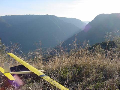
Pictures: The picture above is looking south, toward “Lover’s Leap”,
overlooking the American River. This sixty-inch
span Fun-1, built light with RDS, makes a nice inland slope ship for light lift.
Links:
TerraServer Sat Photo: the thing that looks a big road is the double railroad tracks. The parking area is the small clearing along the north side of the tracks just below the center of the image.
Topozone
topographic map of the site: Just to the right of “BM 3866” is the site,
just to the right of the spring (blue circle with squiggly tail).
Yahoo
Map of Alta and Casa Loma area
Back to the Gold Country Soaring home page
Rob Crockett
December 2000

Looking SE at the primary site.

So where are you planning to land? Brian McLean with his Extreme.

Looking back from the above rock,
south toward the primary site, down the canyon.

View of the Casa Loma site from another
location down the canyon at sunset.