Red Mountain
Slope Soaring Site
Cisco Grove, California
 Description:
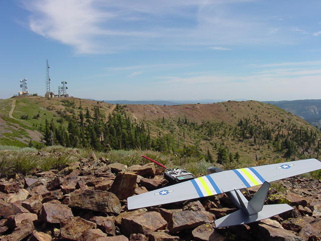
At 7840 feet (2390 m), this is a spectacular site overlooking the
Sierra mountains. An antenna farm occupies the very peak,
and the mountain forms three wide bowls from the peak. The
largest bowl faces south-east, and is at least 3000 feet down a
steep but walkable slope toward I-80. Between the south-east
bowl and the north-west bowl is a razor-back ridge that
seems to make a nice site for dynamic soaring. With no wind
what-so-ever in the valleys, this site will have a respectable
breeze and great lift, thanks to the enormous slope.
However, this is a site for experts only; the altitude
makes the planes fly faster, and landing is a bit dicey with all
the rock (yep they are red). In addition, I'd say that four
wheel drive is a requirement to summit this site, and it's a
seven mile drive in on dirt roads from the freeway.
Description:
At 7840 feet (2390 m), this is a spectacular site overlooking the
Sierra mountains. An antenna farm occupies the very peak,
and the mountain forms three wide bowls from the peak. The
largest bowl faces south-east, and is at least 3000 feet down a
steep but walkable slope toward I-80. Between the south-east
bowl and the north-west bowl is a razor-back ridge that
seems to make a nice site for dynamic soaring. With no wind
what-so-ever in the valleys, this site will have a respectable
breeze and great lift, thanks to the enormous slope.
However, this is a site for experts only; the altitude
makes the planes fly faster, and landing is a bit dicey with all
the rock (yep they are red). In addition, I'd say that four
wheel drive is a requirement to summit this site, and it's a
seven mile drive in on dirt roads from the freeway.
Location: Auburn is about 30 miles
east of Sacramento on I-80. Drive an additional 45 miles
past Auburn, going east on I-80, (about 21 miles west of Truckee)
and turn off at Cisco Grove, which is about 3.8 miles past the
junction of I-80 and I-20. Cross to the north side of the
freeway, drive a block left/west, and turn right/north onto
Fordyce Lake Road, a dirt road. Set your odometer, and at 2.6
and 3.2 miles is the Woodchuck Flat campground. At the fork
at 4.3 miles, continue left toward Fordyce Lake. At the
fork at 5.1 miles, continue left again toward Fordyce Lake.
Just beyond this fork the road forks again but with multiple
paths. Pick the major left/west road (most of the left/west
roads seem to converge within a few hundred feet again), and
follow the main road to the antenna farm at the summit, about 7.2
miles in. From the last fork, the road is rocky and steep
in places, in several areas vaguely resembling a creek bed, but
gets better. There are several large and impressive steel
gates, but these didn't appear funtional and were open.
 Flying the
site and cautions: Since the main flyable bowl faces
south-east, I'd say that the best time to fly would be morning or
early afternoon with the sun on the slope and adiabatic lift
powering the slope. A northwest wind probably would be fine
for the smaller (but still huge) north-west bowl. The north-east
bowl is so steep and cragy and huge, that I didn't want to stand
close enough to really check it out. I'd hate to think what
this place would be like with any serious wind--scary.
Anyway, with light conditions, launch facing south-east, then
dive to the back side over the north-west bowl to check out the
gradient. This site at first glance seems to have nothing
but rocks to land in, but just down from the top there are areas
where bushes cover the rocks completely, and make a reasonable
landing site. The bushes have a fair about of spring to
them, so watch for the rebound pitching the tail back into the
rocks if you put your plane in hot. You can also belly-flop
the plane onto a pile of rocks with little damage to the
plane if you need to--the rocks are amazingly light weight and
scatter when you land your plane.
Flying the
site and cautions: Since the main flyable bowl faces
south-east, I'd say that the best time to fly would be morning or
early afternoon with the sun on the slope and adiabatic lift
powering the slope. A northwest wind probably would be fine
for the smaller (but still huge) north-west bowl. The north-east
bowl is so steep and cragy and huge, that I didn't want to stand
close enough to really check it out. I'd hate to think what
this place would be like with any serious wind--scary.
Anyway, with light conditions, launch facing south-east, then
dive to the back side over the north-west bowl to check out the
gradient. This site at first glance seems to have nothing
but rocks to land in, but just down from the top there are areas
where bushes cover the rocks completely, and make a reasonable
landing site. The bushes have a fair about of spring to
them, so watch for the rebound pitching the tail back into the
rocks if you put your plane in hot. You can also belly-flop
the plane onto a pile of rocks with little damage to the
plane if you need to--the rocks are amazingly light weight and
scatter when you land your plane.
 Bring warm clothes at this
altitude. Yes it does snow here--a lot. And the snow
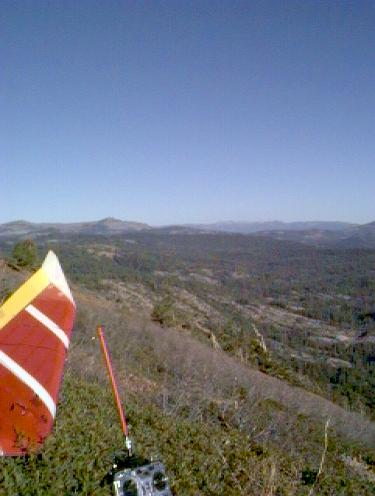
sticks around until nearly summer. From this site you can
look north-east and see Grouse Ridge, another spectacular series
of experts-only soaring sites. If you look directly
west about 16 miles, you can see the bare Basin Peak and Castle
Peak (just above the tiplet) with the rocky saddle ridge between
them (another DS site?).
Bring warm clothes at this
altitude. Yes it does snow here--a lot. And the snow
sticks around until nearly summer. From this site you can
look north-east and see Grouse Ridge, another spectacular series
of experts-only soaring sites. If you look directly
west about 16 miles, you can see the bare Basin Peak and Castle
Peak (just above the tiplet) with the rocky saddle ridge between
them (another DS site?).
Scott Hewett's comments.
Phil Seargent's comments.
Show
me a Yahoo street map. The last part of the road
to the peak is missing in this map, so draw a line from the end
of the right hand road to the end of the left hand road in the
center of the map. Where the new line joins the left road
is the peak of Red Mountain.
Show
me a USGS spycam photo. The circle in the center of the
picture is the antenna farm. At the corner of the "L"
in the road is where the above pictures were taken. You can
easily make out the three bowls.
Enjoy,
Rob Crockett
12/99